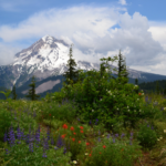
Starting near Zigzag on East Mountain Drive (Forest Road 1819), Zigzag Mountain Trail #775 gains the top of Zigzag Mountain in 3.5 miles and then runs west to east across Mount Hood’s upper south slope, ending at Paradise Park Trail #778 in the Mount Hood Wilderness. The tread is mostly moderately wide single track with some rocky spots.
Along the way you’ll find many views of Mt. Hood, two former lookout sites and huckleberries. Connecting trails such as Horseshoe Ridge, Devil’s Tie, Cast Lake and Burnt Lake make it easy to plan an out-and-back or a shuttle hike. Reliable water is hard to find, so carry plenty.
Trail map & elevation
- Trail class
- Class 3 of 5
- Typical grade
- 12-20%
- Surface
- Native material
- Tread width
- 18-24 inches
- Ranger district
- Zigzag
Connects to: Cast Lake Trail #796, Paradise Park Trail #778, West Zigzag Trail #789, Cast Creek Trail #773, Devils Tie Trail #767, Horseshoe Ridge Trail #774
More about the Mount Hood Wilderness and its trails →
Line, length and trail class: U.S. Forest Service trail data. Elevation: USGS 3D Elevation Program. Difficulty is our estimate for hiking it out and back (once around for a loop), from distance and total climb. Lines can be off by a few hundred feet; carry a real map and check the official page for closures.
Getting there
- Zigzag Mountain trailhead: From Zigzag, turn left (north) on Lolo Pass Road (Forest Road 18) and follow it for 0.3 mile to East Mountain Drive (Forest Road 1819).
- Turn right (east) on East Mountain Drive and follow it for 0.5 mile.
- The trailhead sign is on the left (northeast) side of the road.
- From the east: Follow Paradise Park Trail #778 for 5.3 miles to the junction with Zigzag Mountain Trail #775.
From the Forest Service
Rules and restrictions
Wilderness restrictions apply
Trails nearby
 Cast Lake Trail #796
1 mi round trip
218 ft
Easy
 Paradise Park Trail #778
13.8 mi round trip
3,574 ft
Very hard
 West Zigzag Trail #789
4.6 mi round trip
1,607 ft
Hard
 Cast Creek Trail #773
10.4 mi round trip
3,138 ft
Very hard
 Devils Tie Trail #767
0.6 mi round trip
345 ft
Easy
 Horseshoe Ridge Trail #774
9.2 mi round trip
3,259 ft
Very hard
 Burnt Lake Trail #772
9 mi round trip
1,984 ft
Hard
 Pacific Crest Trail (Zigzag RD)
85.4 mi round trip
16,324 ft
Very hard
Timberline Trail #600
39.2 mi loop
11,267 ft
Very hard
 Paradise Park Loop Trail #757
4.8 mi round trip
1,195 ft
Hard
Boulder Ridge Trail #783A
7.4 mi round trip
3,067 ft
Very hard
Flag Mountain Trail #766
3.8 mi round trip
1,397 ft
Hard