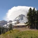
On Mount Hood’s northeast flank, this Nordic route drops about 1,520 feet from near the Snowshoe Cabin at Cloud Cap Inn, at 5,880 feet, to Forest Road 3512, also called Cloud Cap Road, at 4,360 feet. Skiers find it works best heading downhill. Much of the way runs through an old burn, and the trail crosses Cloud Cap Road ten times before it ends.
To reach the top, drive about 22.2 miles south of Hood River on Highway 35 and turn west on Cooper Spur Road. After 2.4 miles, go left on Cloud Cap Road and follow it roughly 9.8 miles to the trailhead by the Snowshoe Cabin.
Getting there
From Hood River, OR
- travel approximately 22.2 miles south on Oregon Hwy 35 and turn right (west) onto Cooper Spur Road.
- Follow Cooper Spur Road 2.4 miles to Cloud Cap Road (Forest Road 3512) and turn left (southeast).
- Follow Cloud Cap Road (Forest Road 3512) approximately 9.8 miles to the trailhead near the Snowshoe Cabin at the Cloud Cap Inn.
From the Forest Service
All fees
A valid Recreation Pass is required at Cloud Cap Trailhead from May 1 to October 31.
Passes and permits
A Recreation Pass may be used as a form of fee payment.
Ranger office
Hood River Ranger District
Address: 6780 Highway 35 Parkdale, OR 97041
Phone: 541-352-6002
Hours: Monday to Friday, 8 a.m. to 3 p.m. Closed 12 to 1 for lunch. (Closed on federal holidays)