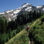
Mazama Trail #625 heads into the Mount Hood Wilderness from a ridge above Ladd Creek, where Mt. Hood rises behind the start. The Mazamas, a local organization devoted to climbing, conservation and responsible recreation, rebuilt the trail in the 1990s as a 100th anniversary project.
Reaching the trailhead means some rough forest road. From Highway 26 at Zigzag, take Lolo Pass Road (Road 18) about 10 miles, turn right on Road 1810 for 5 miles, then right on Road 1811 for 3 miles. From Hood River, come in by way of Highway 35, Woodworth Road, the Dee Highway and the Lost Lake road to Road 18, then follow the same 1810 and 1811 route.
Trail map & elevation
- Trail class
- Class 2 of 5
- Typical grade
- 12-20%
- Surface
- Native material
- Tread width
- 18-24 inches
- Ranger district
- Hood River
More about the Mount Hood Wilderness and its trails →
Line, length and trail class: U.S. Forest Service trail data. Elevation: USGS 3D Elevation Program. Difficulty is our estimate for hiking it out and back (once around for a loop), from distance and total climb. Lines can be off by a few hundred feet; carry a real map and check the official page for closures.
Things to do
- Outdoor Science and Learning
- Viewing
Getting there
From Portland
- Drive Hwy. 26 east to Zigzag.
- Turn on Lolo Pass (Rd. 18), follow it about 10 miles to Rd. 1810 (rough road).
- Take a right and drive 5 miles to Rd. 1811, take a right and drive 3 miles to trailhead.
From Hood River
- Drive Hwy. 35 for about 13 miles to Woodworth Road.
- Travel west on Woodworth Road 3 miles to Dee Highway (281).
- Turn right on Dee Highway for about 5 miles to the Dee Hardwood plant, turn left, drive across bridge, stay left and follow signs to Lost Lake for about 7 miles to Rd. 18.
- Turn left onto Rd. 18 to 1810.
- Follow 1810 to 1811 and drive 3 miles to the trailhead.
From the Forest Service
Rules and restrictions
Group size is limited to 12. Wilderness restrictions apply.
Season details
Usually accessible in June
Trails nearby
 Timberline Trail #600
58.6 mi
16,475 ft
Very hard
 Eden Park Trail #600H
3.4 mi
1,011 ft
Moderate
 Vista Ridge Trail #626
5 mi
1,159 ft
Hard
 McGee Creek Trail #627
3.2 mi
895 ft
Moderate
 Pinnacle Ridge Trail #630
6 mi
2,160 ft
Hard
 Yocum Ridge Trail #771
7.8 mi
2,129 ft
Hard
 Elk Cove Trail #631
10 mi
2,323 ft
Very hard
Top Spur Trail #785
1 mi
348 ft
Easy
 Ramona Falls Trail #797
3.4 mi
589 ft
Moderate
Paradise Park Loop Trail #757
4.8 mi
1,195 ft
Hard