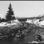
Steep and direct, the Alpine Trail covers 2.1 miles between the Government Camp area and Timberline Lodge. In winter, lots of skiers use it as a downhill run from the lodge back to Government Camp, though cross-country skiers are better off choosing a different route.
Come in summer or early fall and you will find huckleberries in good supply along the trail. From Sandy, head east on Highway 26 past Government Camp and turn left on Timberline Road. After about 5 miles, turn left into Alpine Campground.
Trail map & elevation
- Trail class
- Class 3 of 5
- Typical grade
- 12-20%
- Surface
- Snow
- Tread width
- <12 inches
- Ranger district
- Zigzag
Connects to: Timberline to Town Trail #756, Camp Creek Loop Trail #754, Glade Trail #661, Crosstown Trail #755
Line, length and trail class: U.S. Forest Service trail data. Elevation: USGS 3D Elevation Program. Difficulty is our estimate for hiking it out and back (once around for a loop), from distance and total climb. Lines can be off by a few hundred feet; carry a real map and check the official page for closures.
Getting there
From Sandy
- travel east on Hwy 26 past Government Camp & take left onto Timberline Rd. Travel about 5 miles up Timberline Road and turn left into the Alpine Campground.
Trails nearby
 Timberline to Town Trail #756
9.8 mi round trip
1,851 ft
Hard
 Camp Creek Loop Trail #754
2.4 mi round trip
414 ft
Easy
 Glade Trail #661
5.4 mi round trip
1,920 ft
 Crosstown Trail #755
5.4 mi round trip
618 ft
Moderate
 Barlow Trail #601A
1.4 mi round trip
218 ft
Easy
 Summit Trail #691
4 mi round trip
430 ft
Moderate
 Yellowjacket Trail
10.8 mi round trip
1,317 ft
 Mountaineer Trail #798
2.6 mi loop
1,104 ft
Moderate
Hemlock Trail #691A
1.4 mi round trip
170 ft
 Skiway Trail #755B
1.4 mi round trip
258 ft
Easy
 White Away Trail
1.8 mi round trip
292 ft
Snowbunny Trail
3.6 mi round trip
567 ft