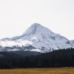
Northwest of Mount Hood, Buck Peak Trail #615 is a brief spur that climbs from the Pacific Crest Trail #2000 at 4,480 feet to the 4,720-foot summit of Buck Peak, and back the same way. Up top you can see Mount Hood and Lost Lake, along with what is left of an old lookout tower.
No road reaches the start, so you will hike the PCT first: 5.7 miles south from the Indian Springs trailhead, a very scenic stretch, or 7.3 miles north from the Lolo Pass trailhead. The trailhead sits on road 1310-660, reached from Lost Lake Road by Forest Roads 13 and 1310. Very few hikers make the side trip.
Trail map & elevation
- Trail class
- Class 1 of 5
- Typical grade
- 12-20%
- Surface
- Native material
- Tread width
- 18-24 inches
- Ranger district
- Hood River
Line, length and trail class: U.S. Forest Service trail data. Elevation: USGS 3D Elevation Program. Difficulty is our estimate for hiking it out and back (once around for a loop), from distance and total climb. Lines can be off by a few hundred feet; carry a real map and check the official page for closures.
Getting there
From Portland, OR
- Head east on I-84 to the junction with Highway 281.
- Connect up with the Lost Lake Rd. At the junction of Lost Lake Rd. and Forest Road 13 head west until you come to the junction with the Forest Road 1310.
- The trailhead is located along the 1310.660 Rd. This trail is accessed by traveling on the Pacific Crest Trail #2000 5.7 miles south of the Indian Springs trailhead or 7.3 miles north of the Lolo Pass Trailhead.
From the Forest Service
Good to know
This trail sees very light use and may not be maintained