
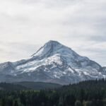
Views of Mount Hood and Boulder Creek are the reward on Forest Creek Trail #473, a more difficult route that pairs with Hidden Meadows Trail #472 for a 6.5-mile loop from Bonney Meadows Campground. It makes a long day hike and a good mountain bike ride.
From the Bonney Meadows Trailhead, take Boulder Lake Trail #463 and then Hidden Meadows Trail a short way to the start. Forest Creek Trail runs 2.4 miles to Forest Road 4881-123, crosses it, and continues 0.7 mile to rejoin Hidden Meadows Trail, which leads a little over 3 miles back. The last stretch of road to the campground is rough and unimproved.
Trail map & elevation
- Trail class
- Class 2 of 5
- Typical grade
- 12-20%
- Surface
- Native material
- Tread width
- 18-24 inches
- Ranger district
- Barlow
Line, length and trail class: U.S. Forest Service trail data. Elevation: USGS 3D Elevation Program. Difficulty is our estimate for hiking it out and back (once around for a loop), from distance and total climb. Lines can be off by a few hundred feet; carry a real map and check the official page for closures.
Getting there
From Tygh Valley, OR
- Follow Wamic Market road for approximately 6 miles.
- Continue onto Rock Creek / White River Road for another 7 miles.
- Once you reach the forest boundary you will be on Forest Road 48 which you will follow for approximately 11 miles.
- Turn right and head North on Forest Road 4890 for 3.6 miles.
- Once you reach a 4-way intersection continue north onto 4891.
- FR 4891 is an unimproved road and may require high clearance or four-wheel drive.
- Follow FR 4891 for 4 miles and the entrance to Bonney Meadows Campground will be on the right.
From Sandy, OR
- Follow Highway 26 East to merge onto Highway 35 North.
- Continue on Hwy 35 for 4.5 miles and turn right onto Forest Road 48.
- Continue on 48 for 6.8 miles.
- Turn left and head North on 4890 for 3.6 miles.
- Once you reach a 4-way intersection continue north onto 4891.
- FR 4891 is an unimproved road and may require high clearance or four-wheel drive.
- Follow FR 4891 for 4 miles and the entrance to Bonney Meadows Campground will be on the right.
From Hood River, OR
- Follow Highway 35 South for 34 miles.
- Turn left onto Forest Road 48.
- Continue on 48 for 6.8 miles.
- Turn left and head North on 4890 for 3.6 miles.
- Once you reach a 4-way intersection continue north onto 4891.
- FR 4891 is an unimproved road and may require high clearance or four-wheel drive.
- Follow FR 4891 for 4 miles and the entrance to Bonney Meadows Campground will be on the right.
- Final stretches of road are unimproved and not recommended for trailers and passenger cars.
From the Forest Service
Good to know
Sections of this trails are maintained thanks to the 44 Trails Association.
Ranger office
Barlow Ranger District
Address: 780 NE Court St Dufur, OR 97021
Phone: 541-467-5100
Hours: Monday to Friday, 8 a.m. to 3 p.m. Closed 12 to 1 for lunch. (Closed on federal holidays)
Trails nearby
 Boulder Lake Trail #463
5.4 mi
1,345 ft
Hard
 Boulder Lakeshore Trail #463B
1 mi
222 ft
Easy
 Little Boulder Trail #463A
1 mi
178 ft
Easy
 Bonney Meadows Trail #471
10.8 mi
3,190 ft
Very hard
 Gunsight Butte Trail #685
10 mi
2,058 ft
Very hard
 Camp Windy Trail #685B
2 mi
388 ft
Easy
 Badger Creek Trail #479
24.4 mi
4,625 ft
Very hard
Divide Trail #458
15.4 mi
4,865 ft
Very hard
 Barlow Butte Trail #670
10 mi
4,075 ft
Very hard
Rocky Butte Trail #475
2.4 mi
667 ft
Moderate
 Jean Lake Trail #680
0.6 mi
249 ft
Easy