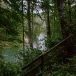
Mountain bikers like Camas Trail #490A, which runs about 3.3 miles from the Camas Prairie Trailhead to an upper trailhead at Keeps Mill Campground, following Camas Creek and Clear Creek. Along the way there are views of the White River Canyon.
From the meadow at Camas Prairie, the trail heads east into thick ponderosa pine. About 1.2 miles in, a short, steep hill brings you up to paved Forest Road 2120-240. Cross it and go 1.75 more miles to Forest Road 2120, then a final 0.35 mile to Keeps Mill. The Camas Prairie trailhead, with a corral just to its west, is off OR 216 east of US 26. Hurricane Racing and the 44 Trails Association help maintain it.
Trail map & elevation
- Trail class
- Class 2 of 5
- Typical grade
- 12-20%
- Surface
- Native material
- Tread width
- 18-24 inches
- Ranger district
- Barlow
Connects to: Clear Creek Trail #487
Line, length and trail class: U.S. Forest Service trail data. Elevation: USGS 3D Elevation Program. Difficulty is our estimate for hiking it out and back (once around for a loop), from distance and total climb. Lines can be off by a few hundred feet; carry a real map and check the official page for closures.
Getting there
From Portland, OR
- take US Hwy 26 45 miles east of Sandy to OR Hwy 216.
- Go east on OR Hwy 216 for 3.5 miles to Forest Road 2120.
- Turn left (north) and follow paved Forest Road 2120 1 mile to the junction with Forest Road 240.
- Turn left (west) on Forest Road 240 (pavement ends shortly) for 1.2 miles to the trailhead at Camas Prairie (there is a corral just west of the trailhead).
- Off-road parking is available.
From the Forest Service
Good to know
Trail maintenance is accomplished thanks to the help of the 44 Trails Association and Hurricane Racing.
Rules and restrictions
No motor bikes allowed.
Ranger office
Barlow Ranger District
Address: 780 NE Court St Dufur, OR 97021
Phone: 541-467-5100
Hours: Monday to Friday, 8 a.m. to 3 p.m. Closed 12 to 1 for lunch. (Closed on federal holidays)